


This is what the future of media looks like | Hamish McKenzie
-
What if the polarizing mess of social media, clickbait headlines and
addictive algorithms isn't a breakdown of media but a transition to
something better? ...
 click to see plan larger
 Free energy is being beamed down to us every day from the sun – and all we have to do is harvest it.
We could build a community energy plant on our roof space. Nobody is using it for anything much – so why not? We can make use of north facing or flat roof areas by mounting photo voltaic arrays (PVA) or solar hot water systems, or even panels to capture heat for hydronic underfloor heating.
Of course we could each install solar technology individually, but some houses don’t have any suitable roof space, while others have more than they can use – so it makes sense to pool together and invest in the infrastructure as a neighbourhood. I imagine it would be much cheaper to do it on-mass too. After we’ve paid off the initial investment, we could all have clean free energy, and use the profits we make from selling power back to the grid to use for ongoing maintenance and upgrades.
The layout design above is the ideal layout, and doesn't take into account shadows from higher density or tree planting. Once I've 'crashed' it together, or considered it, with the other aspects of the design, we should get a more realistic picture.

Bike rack on Brisbane Bus
Sometimes you just don’t feel like riding home, or there’s a howling head wind, or your public transport route involves a 20 minute walk at the end. We need to be able to take bikes on all our buses and trains. They’re working on it in Brisbane, we can’t we make it easier here? A lot of people live in small houses in my neighbourhood, and as densities increase living areas will probably get even smaller. Providing secure bike lockers on the street would make it easier for people to own bikes, especially those not living on the ground floor.
It's also a nice visible "sustainable living marker" - a lot of sustainable design features are not really visible, so it's good to have something which.. I don't know.. declares a sustainable intention.
Hopefully, if we work on it, we can create a bike parking problem too.

Click on image to enlarge
Firstly, we can try to increase the amount of people cycling instead of driving. To start with, we could set up a fine network of bike paths, bike lockers, and a woonerf system:
Bike Lanes: Improve safety and linkages
 On the main roads (Wellington & Gold Street & Alexander Parade) we could replace the existing on-road bike lanes with off road paths in the style which are common in Denmark and the Netherlands.
This would improve safety for cyclists by protecting them from turning or swerving traffic, parking cars and opening car doors, and overtaking motorbikes. It also makes it safer for kids to ride, who are sometimes too unpredictable to ride on the road.
If we want to increase rates of cycling – it’s also important to improve the linkages or connections across the city wide bike network. A bike lane is no good if it doesn't go anywhere, or stops existing for 200m right at a busy intersection. In one sense, this is difficult to address on a local level, on the other hand, if everyone tried to improve their own local bike networks, the larger system would look after itself.
The plan above is the 'ideal' design (as per the approach discussed earlier), when other considerations are included it may not be able to be this extensive.
Before & After Slideshow - showing possible configuration of Wellington Street with bike paths on the same level as pedestrians
 Bike lanes in Copenhagen are commonly configured so that they run alongside the footpath, rather than between parked cars and the traffic. The images in this post are from the great blog Copenhagenize the Planet, which also has this cycle-cam video of a ride through the city: it really shows what a difference it makes to have good consistent, uninterrupted, bike paths to travel on.
 Bike lanes in Copenhagen are commonly configured so that they run alongside the footpath, rather than between parked cars and the traffic. The images in this post are from the great blog Copenhagenize the Planet, which also has this cycle-cam video of a ride through the city: it really shows what a difference it makes to have good consistent, uninterrupted, bike paths to travel on.
Woonerf: Streets are for Playing On
 On the local streets (Charlotte, Hotham and Keele) we could implement a series of Woonerven. The Woonerf is another dutch concept (which translates as something like ‘recreation yard' or maybe 'living street') ; the idea is that you create a zone where pedestrians and cyclists have legal priority over motorists. Vehicles entering the area are restricted to ‘walking pace’ (about 7-10km per hour). Pedestrians, including children, use the entire street and kids are encouraged to play in the street. Yay!
It has the other advantage of encouraging people to keep off 'local traffic' roads unless they are actually local traffic. The City of Yarra (our local council) are looking at putting in a bunch of speed bumps around our neighbourhood to stop drivers taking short cuts through the back streets at peak hour. A property developer who worked for Central Equity once told me that a speed bump outside your house knocks $20 000 off the value the property because of the annoying 'bump-scrape-bump' noise each time a car goes over the hump - I bet nobody ever lost money on their house because the traffic outside passes slowly enough for the local kids to play a game of hopscotch on the street.
 Click on image to see larger
At this stage I’m focusing on the ‘spatial’ elements of the design, that is, those things which require specific spatial configurations (so, for example, at this point bike paths are spatial, but a food buying co-op isn’t).
 The approach I’m taking is borrowed in part from the design process used by Bernard Tschumi for Parc de la Villette in Paris (shown on the right), by thinking about the design in discrete layers.
I've broken down the design proposals into the following layers:
- Road Energy System®
- Rainwater Tanks
- Bike Network
- Earth (or Labyrinth) Cooling
- Planting
- Program
- Solar Hot water heating and PV Array
- Worm Farm & Black Water
Then I've gone ahead and designed each one of these layers in a utopian way, without reference to the other layers. So, for example, I’ve put solar panels in every possible location without considering where I might want to plant trees whose shadows would compromise the panels effectiveness, I’ve laid down the ideal bike path without considering traffic or other uses.
The next step is to ‘crash’ all these layers together. Once I've done that I can decide to either remove conflicts, or else use the conflicts created to generate interesting design solutions. So for example – if I want a PV array in the same location as an area of open space – I could chose one instead of the other – or perhaps I could make them co-exist - a PVA as a sculptural element within a park perhaps, or as part of the roof of a picnic shelter.
I'll follow this up with a post for each layer - giving more details.

After doing a design for a networks city for the surrounding area which I posted earlier, if we zoom in on my neighbourhood – it looks like this.
So we have higher density on Wellington and Alexander Parade, and to a lessor degree on Hotham and Gold Streets. Lower density areas are enclosed within, and we have a green link running down Gold and Charlotte streets, and the area in between. And green combined with high density along Hotham Street.
Now my job is to interpret this drawing into a series of specific design recommendations... stay tuned.
 So an interesting development which affects this project and my neighbourhood, is the proposal to divert additional east-west cross city traffic down Alexander Parade, and build a tunnel to accommodate it.
Local community groups are protesting, and calling for improvements to public transport instead. This makes a lot of sense, the plan I've posted here is from the link on the YCAT site, so it's maybe a little partisan - the dark smoke coming from the stack for example, is perhaps exaggerating the visual impact of the smoke a little (although, probably not the air quality impact). Also, I'm not sure, but the location shown suggests that maybe they are planning to reuse the existing heritage shot tower rather than building a new exhaust stack.
I don't know enough about the tunnel proposal to comment on it specifically. But there's no doubt that catering for and allowing increases in personal car use in the city is incredibly short sighted.
There is just no future for increased car use in the city - logistically as well as environmentally. Every major city in the world has the same problem. Sooner or later you just run out of room for roads. After a critical tipping point, each additional car that passes through the city contributes nothing except to add to congestion, and does it's bit to destroy the qualities of the inner urban area's which we love.
Time to learn from Paris, London, New York and build a decent public transport network which is efficient and well-distributed enough so that every Melbourne resident can choose to use it if they want to (not just those in urban areas, or who are heading into the city).

 In the last post I discussed the idea of "smooth programming", based on Deleuze & Guattari's writings in Mille Plateaus where they distinguish between two types of space: smooth space and striated space.
I came across the website of architect Christian Hubert, where he has this great image of smooth v's striated space, as well as a nice list of oppositions:
- felt / woven fabric
- non-metric / metric multiplicities ( Pierre Boulez)
- primacy of the line (vector) / primacy of the point
- Riemann space / Euclidean space
- becoming / progress
- "free action"(or play?) / work
- haptic / optic ( is perspective a model of striation?)
- local / global (?)
- reading / writing? (De Certeau)
- quality / quantity?
According to Deleuze and Guattari, smooth space is occupied by intensities and events. It is haptic rather than optic, a vectorial space rather than a metrical one. Smooth space is characteristic of sea, steppe, ice and desert. It is occupied by packs and nomads.
For more of Hubert's writings and 'note takings' (on, it looks like, just about any theoretic topic of interest to artists or architects) visit his site.
 click on image to see larger
I’m still working towards a specific sustainable design for my local neighbourhood, but before I can do that, I feel like I need to do some more thinking about how this neighbourhood could potentially fit into the surrounding urban fabric.
So for the plan you see above I’ve applied Steve Whitford’s Networks Cities principles in my design in a similar way to the approach used by BAU in some of their projects in China.
BAU’s approach is illustrated in the diagrams below, (taken from page 94 of Networks Cities). In the first diagram, program has been separated into three alternating bands –residential (yellow), commercial (red) and parkland (green).
 From Networks Cities (pg. 94)
click on image to see larger
It should be noted that the separate bands are not intended to be exclusive – that is to say – they are not zones like you would see in the “Ghetto City”; they’re closer to what planners would call ‘mixed use’. Whitford calls this approach “smooth programming” rather than zoning. And he uses the term 'smooth' in the Deleuzian sense, meaning something along the lines of 'full of potential'. The idea is that each of these bands would contain a concentration of one particular program (or culture or activity), but without excluding any other activity (except ‘dirty’ industry).
 From Networks Cities (pg. 94)
click on image to see larger
Open space x residential
Commercial x commercial
Commercial x open space
Commercial x residential
Residential x residential
Open space x open space
Commercial x commercial
Commercial x open space
Commercial x residential
Residential x residential
Open space x open space
One of the things I like about this design strategy is that by using a simple process with relatively few inputs - you can end up with very complex results. It’s making use of the natural phenomenon of emergence, where “complex systems and patterns arise out of a multiplicity of relatively simple interactions”. The designers job becomes to set up the interactions, observe their development, and then decide what to keep and what to discard. Like in film-making; a critical part of the creating the work is the editing process.
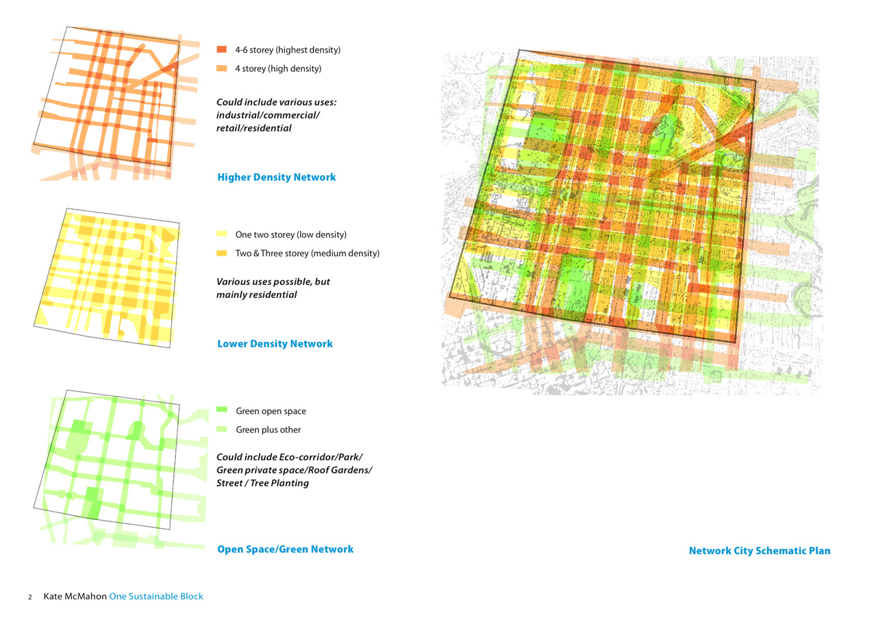
At the top of the post below is my attempt at a networks design for the Local Transport Area (the area shaded yellow here), like the BAU example I’ve broken up the programming into three bands:
- Low Density (mainly residential)
- Medium Density (commercial, retail, residential, industrial etc)
- Green Space (parks, street planting, eco-corridors etc)
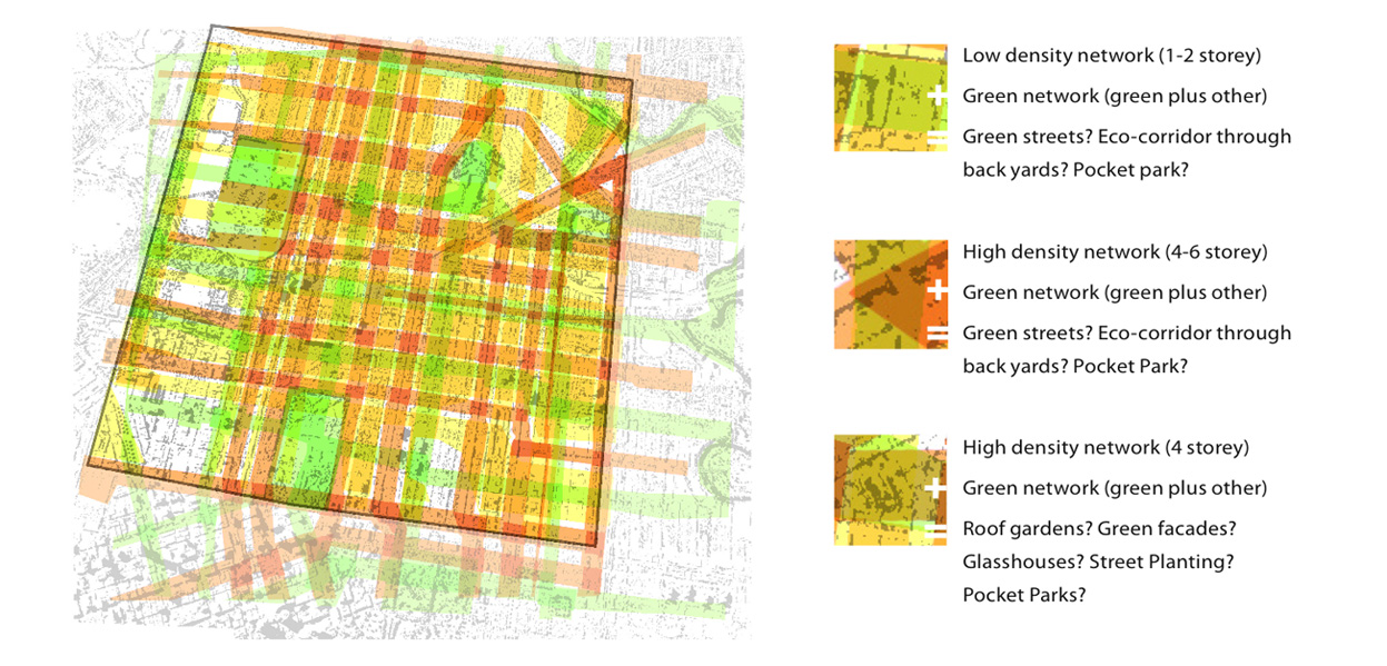
And like the BAU example I've ended up with some interesting and/or areas, where seeming conflicting forms or programs are combined. What do you do if you get open space (green) and highest density (dark orange) 'crashed' together in the same place? Green facades? Roof gardens? High rise green houses?
I've located the bands according to existing conditions, for example, higher density along major road, green networks joining existing open spaces and low density in existing residential areas.
In the next post I'll look at what this process has turned up for my neighbourhood.
click on image to see larger
 I’ve been reading Networks Cities (and their Chinese Application) draft edition edited by James Brearley. The book looks at new urban design and architectural projects in China which have been conceptually driven by using the idea and the form of networks to design how the city should be laid out, especially to decide how program and density should work.
The idea of Networks Cities as it appears in this book, is largely influenced by the work of Steve Whitford; an architect, urban designer and academic at The University of Melbourne. Steve has written an essay in the book where he gives a history of the development of city form/design and a sense of how his networks city fits in: “No Zone City”
Whitford describes this as the city as it was before the introduction of planning – some of the urban spaces most loved by tourists and locals would fall into this category – all those old medieval fortress cities. But they tend to only work on a small scale, they can’t cope with contemporary traffic and other hazards, and Whitford points out - the only way to sort out programming conflicts (i.e someone has built an abattoir next to my second bedroom) is to take it to court after the fact. “Ghetto City”target="new"
This is the zoned city popular in the middle of last century. The kind of city planning which Jane Jacobs rallied against, which separates city activities into discrete enclaves: Industry separated from offices, culture centres separated from retail, retail separated from restaurants. And residential apart from everything else. Besides creating cities which have little pedestrian life, and feel ‘dead’ or ‘boring’ (see Canberra, Brasilia, Chandigarh) – these cities privilege the motor vehicle, and require huge amounts of travel from one program to the other – so they’re not a good solution for sustainability. “Mixed Use City”
A response to the problems of what Steve refers to as the “ghetto city”, this is a bit of a return towards the “No Zone City”. You get the juxtaposition of program again, and the diversity – but on a city wide level it tends to be homogenous. That is to say – one part of the city tends to look and feel like another. “Mosaic City”
This is where Whitford places Alexander’s response to the “Mixed Use City” where he calls for a city made up of little distinct clusters of program or culture or form; which can start as small as 4-6 houses. Whitford calls this a “both/and solution which would no doubt please Robert Venturi.”
These clusters are still mixed use (meaning they mix different programs, for example, retail, open space, residential, together) - but instead of the program being distributed evenly throughout the city, it’s focused in various points throughout the city, creating diversity and a sense of place. “Banded City”
The “banded city” takes Alexander’s clusters and turns them into bands –allowing someone who walks through the city to have a continuous experience, they could choose to have “a green experience, a high culture experience, or a commercial experience”.
Whitford points to Rem Koolhaas’ proposal for the La Villette competition as a precedent – in the proposal a visitor experiences continuous program as long as they walk along a band, if they walk across them “they experience a variety of programs compressed within a short space-time.”
And finally we get to Steve Whitford’s idea of the “Networks City”: “Networks City”
The idea is that you copy the long continuous strips of program that you might find in a “Banded city” and rotate them around and overlay over the original bands to create a lattice.
This way you can travel across the city within one continuous experience – so you could have a “green city experience” or a “retail experience” across the whole city. The city is continuous and connected – while at the same time being diverse. Programs are distributed all through the city without creating homogeneity, or a sense of sameness.“Surprisingly the answer to the question: Where is the housing, the commerce, the (clean) industry? Is everywhere. Importantly the answer to the question: are there ghettos of housing, commerce or (clean) industry? Is no.”
Steve Whitford "Sharpening Blunt Instruments for Better Cities" Networks Cities
I've used this theory as a way to think about how my neighbourhood could fit into a series of sustainable networks. Shortly I'll post a design which is an attempt to think about how density, program and open space could work in my neighbourhood, and in the larger Local Transport Area defined earlier.

“Networks are permeable and open spatial and social structures that facilitate flows of people, ideas, products, information and capital.”
Kim Dovey, Networks Cities (draft)
Today I was riding my bike home from Fairfield for the first time. I checked out my route first on google maps, and was pleased to note that 80% or more of the ride was along an off-road bike trail along the Yarra River (the Capital City bike trail) which goes all the way into the city. All I had to do was roll down the hill from the shopping strip in Fairfield and after a few moments I’d be on the trail which would take me most of the way home.
As I left Fairfield shops and rode along the merrily south along the on-road bike lane approaching a major intersection when the bike lane just... disappeared.
View Larger Map
After a bit of illegal and potentially dangerous manoeuvring I managed to make it to the off-road trail. But the experience made me think about networks, and how important holistic thinking is for thinking about ways to make my neighbourhood more sustainable
In a way, holistic thinking, or thinking about the ways in which elements inter-relate to each other, is central to sustainable design.
At the risk of gross overgeneralisation; traditional design processes tend to focus on discrete objects or design elements, rather than the relationships or dynamics between elements and objects.
So, in this example, I imagine that council would have a range of design professionals who contribute to the location of bike paths: A landscape architect (or open-space/recreation person) probably designed a cycling master plan, linking as many existing bike tracks together as possible. As part of this hypothetical master plan, an on-road bike path was recommended to link the shops & train station with the Yarra River and the off-road trail. I know it once existed, because you can still see the faint marking of it carrying through the intersection.
At a later date, let’s speculate, a traffic engineer has come along. This persons job is to try to speed up the traffic and reduce the likelihood of car crashes, in other words – their job is to think about the network that services cars. They don’t have to worry about bikes, or transport in general, or carbon in the atmosphere – they just have to think about cars, that one intersection and the immediate surrounding area of traffic.
So, it’s a no brainer: Take out the bike path, and the intersection is safer, and more efficient. That is to say; it’s safer, and more efficient for cars. It’s certainly not safer or more efficient for bicycles.
Of course; I’m just guessing here, perhaps the traffic engineers and the open space planners and the landscape architects got together and workshopped all the different variables and needs of different stakeholders and this was the best solution. But I’ve got to say – I doubt it.
If we want to see more sustainable design outcomes, the first step is to change our design processes. Our design professionals, that is to say; our engineers, planners, landscape architects, resource managers, architects and urban designers have to find ways to collaborate, early and often on design projects. And as designers we also need to find more holistic ways to approach design within our own areas of expertise. We need to think and design more rhizomatically, we need to do more network thinking, we need to consider whole systems rather than focus on discrete elements.
The reason cars dominate our cities and neighbourhoods so much, or rather, the means by which they are able to do so is because they make use of a strong and unbroken network. A good way to make our cities more sustainable is to create strong unbroken networks which will allow the flow of alternative means of transportation, energy and ideas.
$2000, a trip to beautiful Melbourne, and the warm inner glow that comes from helping to save the planet...
0 comments Posted by Kate McMahon at 9:05 pmAll this can be yours if you take part in this international student design competition being held as part of SB08 World Sustainable Building Conference
The aim of this competition is to transform an existing historic waste transfer station in Melbourne, Australia using symbiotic and ecological design principles to create a no-waste housing development. Approximately 45 houses need to be accommodated on the site which can vary from single to four stories. Shortlisted submissions will be displayed at the SB08 World Sustainable Building Conference in Melbourne, Australia
September 21st - 27th 2008
Key Dates:
Submission Deadline: 20th August, 2008
Charette and Decisions: 20th September, 2008
More info here.
I've just been listening to a podcast of the Science Show on Radio National, which went to air in June. Chilling stuff (no pun intended).
Tim Flannery has been tracking the accelerating rate of ice melt in the poles, and concludes that if the ice melt continues at the rate which has been recorded in the last three years; we could lose "half the remaining sea ice by the end of this northern summer".
Half.
This made me think of another Bertrand Russell quote:
"Most people would die sooner than think — in fact they do so."I've been wondering how radical I should be with my design, and what people will accept. Trying to find ways to 'insert' sustainability without affecting the aspects of living in this part of Melbourne which people enjoy. Asking myself how to change people's habits, and more to the point, asking myself how I can change my own habits. But if Tim Flannery is right, we might not have time to make changes, it might already be too late to turn ourselves around. Five years!
Excerpt from the transcript of the program:
Tim Flannery: Up to 2005 it looked as if there'd still be some sea ice by the end of this century in the Arctic. But in 2005 the sea ice started to melt away at about four times the rate of previous years, and that's now continued. And this year, the start of this summer has been just terrifying. The sea ice is melting away at about 6,000 square kilometres greater rate per week than last year. And if this summer follows the trajectory of the last few summers, we stand to lose about half the remaining sea ice by the end of this northern summer. And that is putting us on a trajectory to an ice-free Arctic within five years or so.
Alexandra de Blas: And what are the implications of that?
Tim Flannery: Well, the implications are profound because once the ice is gone the surface levels of the Arctic Ocean will start warming quite rapidly, because it's a dark surface and it absorbs light energy and turns it into heat energy. So the thermal balance of the area around Greenland will change, we'll start getting warming, so we can expect an accelerated rate of melt in Greenland. And that ice cap has enough water frozen in it, were it all to melt, to raise sea levels by six or seven metres. So that's one thing.
The second thing is of course that the entire climatic zonation of the northern hemisphere is held in place by the thermal gradient between the pole and the equator. That's why we have deserts where we have them in the northern hemisphere, and we have forested areas where we have them and tundra where we have them. And when I look at the melting tundra, the advance of the forest northwards...Greece and its forest fires that look like that area's becoming hostile to the sort of vegetation. I think we're seeing the early stages of a shift in that zonation. Once the ice melts away entirely and we get a rapid warming of the Arctic Ocean, that's when you'll see those sorts of changes potentially start shifting much more quickly.
Alexandra de Blas: If the sea ice is gone, say, within five years, how rapidly will we expect the Greenland ice cap to start melting?
Tim Flannery: Again, it's just not possible to answer that question, principally because ice doesn't just melt away as you might imagine an ice cube sitting on a bench would. It melts away, in part at least, by large-scale collapse. So ice shelves tend to collapse into the ocean and then fragment and then melt much more rapidly than they may otherwise do. And that sort of collapse is just impossible to model. We've seen it occur in the Antarctic Peninsula with the Larsen B ice shelf, but it is just impossible to model so we don't know. But people are now I think quite realistically talking about sea level rise, if nothing's done, of several metres this century.
Alexandra de Blas: Which will be astounding.
Tim Flannery: That will mean probably hundreds of millions of people displaced, a lot of the world's best agricultural land lost, some of the world's great cities threatened or under water, places like Shanghai and Amsterdam and London and so forth. Amsterdam's about two-and-a-half metres under water as it is, just held up by the dykes. And Singapore and so forth. So the changes, if you want to sum them up, that's the end of our global civilisation. The stresses that would be placed upon the global political system and economic system would be such that it simply couldn't endure them.
"Humankind has become so much
one family that we cannot insure our
own prosperity except by insuring
that of everyone else."
A few families in India got together to combine their group purchasing power. It's now a large scale purchasing and distribution organisation (Mumbai Grahak Panchayat (MGP)) which caters for 21000 families. The consumers are rewarded with cheaper groceries, and because they order their shopping and have it delivered, they avoid impulse buying.
They're helping the planet by reducing emissions from transportation (estimated at 52000km pa), by only supplying healthy foods, and by demanding less & more sustainable packaging.
There's no reason that this wouldn't work here in Melbourne. An organisation like this could source food which is organic/seasonal or has low food miles & provide it at affordable prices that could compete with supermarket rates
I love that this group started at back-yard get together scale, and now turns over 6 million a year.
Read more here in Choice magazine.
After doing some additional reading – I’ve redefined the neighbourhood boundaries. Initially I just centred the ‘block’ or neighbourhood around our house, besides being, well, a little egocentric, this created problems because it leaves a little area to the north stranded between our neighbourhood and Alexander Parade. Alexander Parade is a major road and too much of a social & physical barrier to have running thought the middle of a community. So, as there are not really enough houses to consider treating as a separate community, for the purposes of this project, I’ve merged them into ours.
Below I’ve worked out six ‘neighbourhoods’ based on Alexander’s principles. I’ve also decided to work on this scale because it makes sense practically – it’s large enough to sustain some fairly large scale sustainable interventions, but small enough to be managed locally and have effective individual involvement.
It would make sense to break this down again if people started putting this design into action, into smaller “housing clusters” or “action groups” (8-12 households, 20-50 people)
So ‘my neighbourhood’ becomes the area defined by Alexander Pde, Gold Street, Wellington Street and Hotham Street. The area highlighted on the plan below; it has about 400 residents, and is roughly 220x200m.

As discussed in earlier posts, I've been reading "A Pattern Language" to get some theoretical guidance for sustainable urban design decisions. Alexander recommended that as much local control as possible should be given over to small communities of 7000 (max. 10 000). His argument is that in communities larger than 10 000 the individual has no effective voice, he also points out the historical precedents for this model: Sophocles ideas & Athenian democracy, Jefferson's ward republic and Confucian principles.
As it happens the suburb of Collingwood is already pretty much a Community of 7000 in terms of population - there's about 5500 residents plus many more business owners and other stakeholders.
The area shown is bounded by Alexander Pde to the north, and Hoddle, Victoria Parade and Smith Street (going clockwise).
Alexander's pattern:
- As nearly as possible; use natural geographic and historical boundaries to mark these communities.
- Give each community the power to initiate, decide, and execute the affairs that concern it closely; land use, housing, maintenance, streets, parks, police, schooling, welfare, neighbourhood services.
 Collingwood as a 'Community of 7000' shown in red, our neighbourhood outlined in orange
![]()
If I apply Alexander's concept of a Local Transport Area to this part of Melbourne then I end up with an area 3.2km across bounded by Hoddle Street to the east, Brunswick Road to the north, Royal Parade to the east and Victoria Parade to the south.
It takes in Fitzroy, Collingwood, Carlton and most of Princes Hill, Clifton Hill, Parkville, Princes Hill, Carlton North and Fitzroy North. The squiggly line to the east is the Yarra River.
The area is squarer than what Alexander proposes; he prefers long sausage like developments. But it is bounded by major roads, which together could act as a ring road.
If you were to apply Alexander's theories here (not that I’m necessarily proposing to) then you would make travel on the ring road fast and efficient, and make motor vehicular transport within it slow, inconvenient and expensive.
You would have few cross streets within the ring roads bounding the LTA and privilege bikes and pedestrian traffic. Local Transport Areas would be well serviced within by public transport and well connected to each other. Each LTA would have a distinct identity and be well defined physically (a massive ring road would do that I guess).


According the great blog Copenhagenize (the planet), in Denmark you can now borrow a bike and trailer at Ikea to get your stuff home. Apparently 20% of customers in Copenhagen ride to the store, even though both stores are located in a 'box industrial' area 10km & 20km outside of town.
We went to 'Hell' lately (as my partner has christened ikea, in response to the labyrinthine- daylight-depriving- endurance sport which is shopping there) and we bought a whole bunch of stuff including a black board, table and chair set, bibs and cushions etc - and we managed to get it all (and us) into the Christiania.
Of course Ikea is really not far us, 3-4km maybe, so I reckon a lot of people would ride if they could.
Key Dimensions & Spatial Relationships for Sustainability
0 comments Posted by Kate McMahon at 2:35 pmBelow is a kind of check list of dimensions which are useful for urban design and planning projects.
These numbers & areas could be used to layout a sustainable township from scratch, but they're also useful for me for this project because it gives me a set of principles to work with. For example - if I want to propose that Charlotte Street be transformed into a linear park I need to be able to justify open space amenity in that location in relation to the rest of the city.
I will also use these principles to work out where the boundaries of 'my neighbourhood' should be.
Some of the figures below come from principles of New Urbanism, some from Superbia, some from Christopher Alexander.
From a Pattern Language - Alexander:
Metropolis
Ideal downtown area which can provide "magic of the city" without over-population and urban sprawl issues.
- Max 1.6km wide (but can be long)
- 300 000 people within 5-23km of each other
- Shopping streets – one for every 10 000 people; 2.9km apart
- Markets of many shops - one for every 4000 people; 1.8km
- Corner groceries one for every 1 000 people; 0.8km apart
Local Transport Area
Urban area should be broken down into local transport areas connected by efficient road transport (ring roads), however traveling within these areas should be slow and inconvenient for motor vehicles.
- 1.6 to 3.2 km across
- Surrounded by a ring road
- Slow moving local traffic and bikes within ring road
- One way parallel streets for connecting traffic (very few cross streets)
Communities of 7000
Communities of 5000 to 10,000 persons with local government control.
- 400m to 3.2km across
- About 30 HA
- Maximum 10 0000 people
- Densities of 125 people per HA will support a promenade within 5-10 minute walk (460m) (Collingwood density is 50 people per HA)
Mosaic of Subculture
Small urban areas with distinct character, lifestyle and culture.
- 50-400m across
Neighbourhoods
Identifiable neighbourhood with some local control
- 90 - 275m across with about 400-500 residents
Housing Cluster
- 8-12 households (about 30-50 people)
- can be as few as 3 households
Work Community
Workplaces organised as communities
- 10-20 work places
Commute
- People should commute a maximum 20-30 minutes
General:
Grassroots
- 500-1500 amount of people who can ‘rally together’
Ped sheds
- 5 minute walk (400m radius) based on new urbanist ‘walkability’ principle
From "Superbia":
- 25-40 houses – optimal number of houses where occupants can get to know each other well and share facilities
- 14m – the distance where you can recognise an individual
"You have to love the area you're trying to change"
Jane Jacobs
(possibly paraphrased a little)
(possibly paraphrased a little)
I've been reading "A Pattern Language" by Christopher Alexander (in collaboration with Sarah Ishikawa and Murray Silverstein) to get a sense of what, theoretically, should be included in a sustainable neighbourhood, and how on could create a 'mental framework' for a neighbourhood.
At the same time I'm reading about PVA arrays and black water mining, but first I want to get my head around ideas like: How big should the neighbourhood be? What building heights are better? What is the ideal density, or ideal combination of densities? And so on...
"A Pattern Language" is almost 30 years old, but, perhaps surprisingly, is still an extremely useful and relevant text. The book provides 253 'patterns' for developing neighbourhoods, towns and cities. It's a little like a repertory cookbook; and each patterns is like a recipe which can be used to guide design decisions from the grand scale of laying out a city, all the way down to the best arrangement of chairs in your kitchen.
The other thing that is interesting about Alexander, and which makes him a useful reference for people interesting in improving 'their own backyard', is that he believes in bottom up change which responds to specific local conditions.“We do not believe that these large patterns, which give so much structure to a town or of a neighborhood, can be created by centralised authority, or by laws, or by master plans. We believe instead that they can emerge gradually and organically almost of their own accord, if every act of building, large or small, takes on the responsibility for gradually shaping it’s small corner of the world to make these larger patterns appear there.”
Listed below are the 'recipes' which I am planning to try and apply (theoretically) to my neighbourhood:
8. Mosaic of Subcultures **
9. Scattered Work **
10. Magic of the City
11. Local Transport Areas **
12. Community of 7000 *
13. Subculture Boundary *
14. Identifiable Neighborhood **
15. Neighborhood Boundary *
16. Web of Public Transportation *
17. Ring Roads
18. Network of Learning
19. Web of Shopping *
20. Mini-Buses *
21. Four-Story Limit **
22. Nine Percent Parking **
23. Parallel Roads
24. Sacred Sites *
25. Access to Water *
26. Life Cycle *
27. Men and Women
28. Eccentric Nucleus *
29. Density Rings *
30. Activity Nodes **
31. Promenade **
32. Shopping Street
33. Night Life *
34. Interchange
37. House Cluster **
41. Work Community **
42. Industrial Ribbon *
43. University as a marketplace
44. Local Town Hall *
47. Health Center *
48. Housing In Between **
63. Dancing in the Street *
64. Pools and Streams *
65. Birth Places
67. Common Land **
68. Connected Play *
69. Public Outdoor Room **
70. Grave Sites *
71. Still Water *
72. Local Sports *
73. Adventure Playground
74. Animals
84. Teenage Society
85. Shopfront Schools
87. Individually Owned Shops **
88. Street Café **
89. Corner Grocery *
90. Beer Hall
91. Traveler's Inn *
92. Bus Stop *
93. Food Stands *
94. Sleeping in Public
120. Paths and goals *
The * markers are Alexander's. He recognises that some of the patterns are "more true, more profound, more certain, than others". Those marked with two asterisks ** are patterns which the authors believe are essential to all good design solutions for the particular problem/situation they pertain to; while the patterns marked with one * are likely to reflect characteristics present in most good design solutions, and those with no asterisks more in the way of suggestions or possiblities.
Summaries of each of Alexander's patterns can be found here. And I will return to some of these if necessary to give some background on design decisions.
Subscribe to:
Posts (Atom)