


This is what the future of media looks like | Hamish McKenzie
-
What if the polarizing mess of social media, clickbait headlines and
addictive algorithms isn't a breakdown of media but a transition to
something better? ...
Showing posts with label networks cities. Show all posts
Showing posts with label networks cities. Show all posts
 Click on image to see larger
At this stage I’m focusing on the ‘spatial’ elements of the design, that is, those things which require specific spatial configurations (so, for example, at this point bike paths are spatial, but a food buying co-op isn’t).
 The approach I’m taking is borrowed in part from the design process used by Bernard Tschumi for Parc de la Villette in Paris (shown on the right), by thinking about the design in discrete layers.
I've broken down the design proposals into the following layers:
- Road Energy System®
- Rainwater Tanks
- Bike Network
- Earth (or Labyrinth) Cooling
- Planting
- Program
- Solar Hot water heating and PV Array
- Worm Farm & Black Water
Then I've gone ahead and designed each one of these layers in a utopian way, without reference to the other layers. So, for example, I’ve put solar panels in every possible location without considering where I might want to plant trees whose shadows would compromise the panels effectiveness, I’ve laid down the ideal bike path without considering traffic or other uses.
The next step is to ‘crash’ all these layers together. Once I've done that I can decide to either remove conflicts, or else use the conflicts created to generate interesting design solutions. So for example – if I want a PV array in the same location as an area of open space – I could chose one instead of the other – or perhaps I could make them co-exist - a PVA as a sculptural element within a park perhaps, or as part of the roof of a picnic shelter.
I'll follow this up with a post for each layer - giving more details.

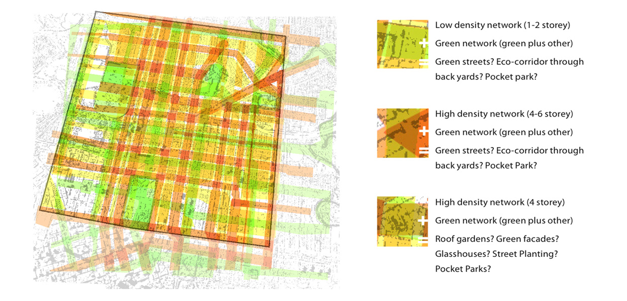
After doing a design for a networks city for the surrounding area which I posted earlier, if we zoom in on my neighbourhood – it looks like this.
So we have higher density on Wellington and Alexander Parade, and to a lessor degree on Hotham and Gold Streets. Lower density areas are enclosed within, and we have a green link running down Gold and Charlotte streets, and the area in between. And green combined with high density along Hotham Street.
Now my job is to interpret this drawing into a series of specific design recommendations... stay tuned.
 In the last post I discussed the idea of "smooth programming", based on Deleuze & Guattari's writings in Mille Plateaus where they distinguish between two types of space: smooth space and striated space.
I came across the website of architect Christian Hubert, where he has this great image of smooth v's striated space, as well as a nice list of oppositions:
- felt / woven fabric
- non-metric / metric multiplicities ( Pierre Boulez)
- primacy of the line (vector) / primacy of the point
- Riemann space / Euclidean space
- becoming / progress
- "free action"(or play?) / work
- haptic / optic ( is perspective a model of striation?)
- local / global (?)
- reading / writing? (De Certeau)
- quality / quantity?
According to Deleuze and Guattari, smooth space is occupied by intensities and events. It is haptic rather than optic, a vectorial space rather than a metrical one. Smooth space is characteristic of sea, steppe, ice and desert. It is occupied by packs and nomads.
For more of Hubert's writings and 'note takings' (on, it looks like, just about any theoretic topic of interest to artists or architects) visit his site.
 click on image to see larger
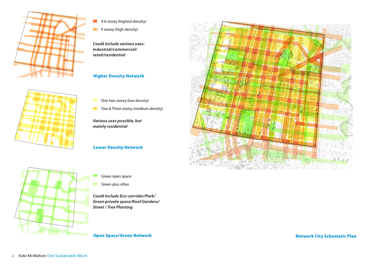
I’m still working towards a specific sustainable design for my local neighbourhood, but before I can do that, I feel like I need to do some more thinking about how this neighbourhood could potentially fit into the surrounding urban fabric.
So for the plan you see above I’ve applied Steve Whitford’s Networks Cities principles in my design in a similar way to the approach used by BAU in some of their projects in China.
BAU’s approach is illustrated in the diagrams below, (taken from page 94 of Networks Cities). In the first diagram, program has been separated into three alternating bands –residential (yellow), commercial (red) and parkland (green).
 From Networks Cities (pg. 94)
click on image to see larger
It should be noted that the separate bands are not intended to be exclusive – that is to say – they are not zones like you would see in the “Ghetto City”; they’re closer to what planners would call ‘mixed use’. Whitford calls this approach “smooth programming” rather than zoning. And he uses the term 'smooth' in the Deleuzian sense, meaning something along the lines of 'full of potential'. The idea is that each of these bands would contain a concentration of one particular program (or culture or activity), but without excluding any other activity (except ‘dirty’ industry).
 From Networks Cities (pg. 94)
click on image to see larger
Open space x residential
Commercial x commercial
Commercial x open space
Commercial x residential
Residential x residential
Open space x open space
Commercial x commercial
Commercial x open space
Commercial x residential
Residential x residential
Open space x open space
One of the things I like about this design strategy is that by using a simple process with relatively few inputs - you can end up with very complex results. It’s making use of the natural phenomenon of emergence, where “complex systems and patterns arise out of a multiplicity of relatively simple interactions”. The designers job becomes to set up the interactions, observe their development, and then decide what to keep and what to discard. Like in film-making; a critical part of the creating the work is the editing process.
At the top of the post below is my attempt at a networks design for the Local Transport Area (the area shaded yellow here), like the BAU example I’ve broken up the programming into three bands:
- Low Density (mainly residential)
- Medium Density (commercial, retail, residential, industrial etc)
- Green Space (parks, street planting, eco-corridors etc)
And like the BAU example I've ended up with some interesting and/or areas, where seeming conflicting forms or programs are combined. What do you do if you get open space (green) and highest density (dark orange) 'crashed' together in the same place? Green facades? Roof gardens? High rise green houses?
I've located the bands according to existing conditions, for example, higher density along major road, green networks joining existing open spaces and low density in existing residential areas.
In the next post I'll look at what this process has turned up for my neighbourhood.
click on image to see larger
 I’ve been reading Networks Cities (and their Chinese Application) draft edition edited by James Brearley. The book looks at new urban design and architectural projects in China which have been conceptually driven by using the idea and the form of networks to design how the city should be laid out, especially to decide how program and density should work.
The idea of Networks Cities as it appears in this book, is largely influenced by the work of Steve Whitford; an architect, urban designer and academic at The University of Melbourne. Steve has written an essay in the book where he gives a history of the development of city form/design and a sense of how his networks city fits in: “No Zone City”
Whitford describes this as the city as it was before the introduction of planning – some of the urban spaces most loved by tourists and locals would fall into this category – all those old medieval fortress cities. But they tend to only work on a small scale, they can’t cope with contemporary traffic and other hazards, and Whitford points out - the only way to sort out programming conflicts (i.e someone has built an abattoir next to my second bedroom) is to take it to court after the fact. “Ghetto City”target="new"
This is the zoned city popular in the middle of last century. The kind of city planning which Jane Jacobs rallied against, which separates city activities into discrete enclaves: Industry separated from offices, culture centres separated from retail, retail separated from restaurants. And residential apart from everything else. Besides creating cities which have little pedestrian life, and feel ‘dead’ or ‘boring’ (see Canberra, Brasilia, Chandigarh) – these cities privilege the motor vehicle, and require huge amounts of travel from one program to the other – so they’re not a good solution for sustainability. “Mixed Use City”
A response to the problems of what Steve refers to as the “ghetto city”, this is a bit of a return towards the “No Zone City”. You get the juxtaposition of program again, and the diversity – but on a city wide level it tends to be homogenous. That is to say – one part of the city tends to look and feel like another. “Mosaic City”
This is where Whitford places Alexander’s response to the “Mixed Use City” where he calls for a city made up of little distinct clusters of program or culture or form; which can start as small as 4-6 houses. Whitford calls this a “both/and solution which would no doubt please Robert Venturi.”
These clusters are still mixed use (meaning they mix different programs, for example, retail, open space, residential, together) - but instead of the program being distributed evenly throughout the city, it’s focused in various points throughout the city, creating diversity and a sense of place. “Banded City”
The “banded city” takes Alexander’s clusters and turns them into bands –allowing someone who walks through the city to have a continuous experience, they could choose to have “a green experience, a high culture experience, or a commercial experience”.
Whitford points to Rem Koolhaas’ proposal for the La Villette competition as a precedent – in the proposal a visitor experiences continuous program as long as they walk along a band, if they walk across them “they experience a variety of programs compressed within a short space-time.”
And finally we get to Steve Whitford’s idea of the “Networks City”: “Networks City”
The idea is that you copy the long continuous strips of program that you might find in a “Banded city” and rotate them around and overlay over the original bands to create a lattice.
This way you can travel across the city within one continuous experience – so you could have a “green city experience” or a “retail experience” across the whole city. The city is continuous and connected – while at the same time being diverse. Programs are distributed all through the city without creating homogeneity, or a sense of sameness.“Surprisingly the answer to the question: Where is the housing, the commerce, the (clean) industry? Is everywhere. Importantly the answer to the question: are there ghettos of housing, commerce or (clean) industry? Is no.”
Steve Whitford "Sharpening Blunt Instruments for Better Cities" Networks Cities
I've used this theory as a way to think about how my neighbourhood could fit into a series of sustainable networks. Shortly I'll post a design which is an attempt to think about how density, program and open space could work in my neighbourhood, and in the larger Local Transport Area defined earlier.

“Networks are permeable and open spatial and social structures that facilitate flows of people, ideas, products, information and capital.”
Kim Dovey, Networks Cities (draft)
Today I was riding my bike home from Fairfield for the first time. I checked out my route first on google maps, and was pleased to note that 80% or more of the ride was along an off-road bike trail along the Yarra River (the Capital City bike trail) which goes all the way into the city. All I had to do was roll down the hill from the shopping strip in Fairfield and after a few moments I’d be on the trail which would take me most of the way home.
As I left Fairfield shops and rode along the merrily south along the on-road bike lane approaching a major intersection when the bike lane just... disappeared.
View Larger Map
After a bit of illegal and potentially dangerous manoeuvring I managed to make it to the off-road trail. But the experience made me think about networks, and how important holistic thinking is for thinking about ways to make my neighbourhood more sustainable
In a way, holistic thinking, or thinking about the ways in which elements inter-relate to each other, is central to sustainable design.
At the risk of gross overgeneralisation; traditional design processes tend to focus on discrete objects or design elements, rather than the relationships or dynamics between elements and objects.
So, in this example, I imagine that council would have a range of design professionals who contribute to the location of bike paths: A landscape architect (or open-space/recreation person) probably designed a cycling master plan, linking as many existing bike tracks together as possible. As part of this hypothetical master plan, an on-road bike path was recommended to link the shops & train station with the Yarra River and the off-road trail. I know it once existed, because you can still see the faint marking of it carrying through the intersection.
At a later date, let’s speculate, a traffic engineer has come along. This persons job is to try to speed up the traffic and reduce the likelihood of car crashes, in other words – their job is to think about the network that services cars. They don’t have to worry about bikes, or transport in general, or carbon in the atmosphere – they just have to think about cars, that one intersection and the immediate surrounding area of traffic.
So, it’s a no brainer: Take out the bike path, and the intersection is safer, and more efficient. That is to say; it’s safer, and more efficient for cars. It’s certainly not safer or more efficient for bicycles.
Of course; I’m just guessing here, perhaps the traffic engineers and the open space planners and the landscape architects got together and workshopped all the different variables and needs of different stakeholders and this was the best solution. But I’ve got to say – I doubt it.
If we want to see more sustainable design outcomes, the first step is to change our design processes. Our design professionals, that is to say; our engineers, planners, landscape architects, resource managers, architects and urban designers have to find ways to collaborate, early and often on design projects. And as designers we also need to find more holistic ways to approach design within our own areas of expertise. We need to think and design more rhizomatically, we need to do more network thinking, we need to consider whole systems rather than focus on discrete elements.
The reason cars dominate our cities and neighbourhoods so much, or rather, the means by which they are able to do so is because they make use of a strong and unbroken network. A good way to make our cities more sustainable is to create strong unbroken networks which will allow the flow of alternative means of transportation, energy and ideas.
Subscribe to:
Posts (Atom)